Back نهر بوك الجنوبي Arabic نهر بوك الجنوبى ARZ Bug (kuksa) AVK Cənubi Buq Azerbaijani بوق جنوبی چایی AZB Көньяҡ Буг Bashkir Паўднёвы Буг Byelorussian Паўднёвы Буг BE-X-OLD Южен Буг Bulgarian Boug ar C'hreisteiz Breton
| Southern Bug | |
|---|---|
 | |
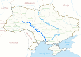
 Southern Bug through Ukraine | |
| Native name | Південний Буг (Ukrainian) |
| Location | |
| Country | Ukraine |
| Physical characteristics | |
| Source | |
| • location | Khmelnytskyi Oblast, Ukraine |
| Mouth | |
• location | Bug estuary, Ukraine |
| Length | 806 km (501 mi) |
| Basin size | 63,700 km2 (24,600 sq mi) |
| Discharge | |
| • average | 108 m3/s |
| Basin features | |
| Progression | Dnieper–Bug estuary→ Black Sea |

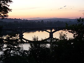
The Southern Bug, also called Southern Buh[1] (Ukrainian: Південний Буг, romanized: Pivdennyi Buh; Russian: Южный Буг, romanized: Yuzhny Bug; Romanian: Bugul de Sud or just Bug),[1] and sometimes Boh River (Ukrainian: Бог; Polish: Boh),[2] is a navigable river located in Ukraine. It is the second-longest river in Ukraine.
The source of the river is in the west of Ukraine, in the Volyn-Podillia Upland, about 145 kilometres (90 miles) from the Polish border, from where it flows southeasterly into the Bug Estuary (Black Sea basin) through the southern steppes. It is 806 kilometres (501 miles) long and drains 63,700 square kilometres (24,600 sq mi).[3]
Several regionally important cities and towns in Ukraine are located on the Southern Bug. Beginning in Western Ukraine and moving downstream, in a southeasterly direction, they are: Khmelnytskyi, Khmilnyk, Vinnytsia, Haivoron, Pervomaisk, Voznesensk and Mykolaiv.[3]
Between 1941 and 1944 during World War II the Southern Bug formed the border between German-occupied Ukraine and the Romanian-occupied part of Ukraine, called Transnistria.
- ^ a b "Encyclopædia Britannica: Southern Buh (River)". Encyclopædia Britannica. Retrieved May 8, 2011.
- ^ Boh River at the Encyclopedia of Ukraine
- ^ a b Южный Буг, Great Soviet Encyclopedia
© MMXXIII Rich X Search. We shall prevail. All rights reserved. Rich X Search